Browser-based GIS solutions without installation requirements for municipalities, airports, and technical decision support teams.
About Our Geoinformatics Systems
The online geoinformatics systems developed by Ecomosaic Ltd. provide spatial analysis capabilities typically available through desktop GIS software, accessible via a web interface. To support decision-makers, our company offers a wide range of orthophoto maps and vector-based evaluation layers, both in terms of resolution and thematic content, which are fully integrable into the system.
Our system does not require software installation, as it operates through an online platform, making the map system accessible on an unlimited number of computers and mobile devices via internet browsers. This ensures easy access to databases regardless of location or working environment. It also allows for the internal management of sensitive map and background information within a network, ensuring that data stored within the organisation is not accessible externally, while permissions can be assigned by department. In such cases, data access and storage are physically separated from the publicly available system on the internet.
The Most Advanced Geoinformatics User Interface
No installation required, operates via browser
Multi-level authorisation, group or individual authentication
Responsive user interface (HTML5, CSS3), suitable for desktops, tablets, and mobile phones
Optimised operations and functions per project (measurements, printing, shared evaluation processes between workstations, support for simultaneous data uploads and moderation by field teams, editing, exporting, importing, complex queries, search, and more)
Cutting-edge geoinformatics standards
Full data compatibility
Integration of open-source technologies (OpenLayers, Apache)
Compatibility with desktop software (QGIS, AutoCAD Map, Global Mapper, etc.)
Data collection, organisation, operations, visualisation, planning
How the Online Geoinformatics System Supports Municipalities and the Public
Provides public information through a map-based website
Offers decision support to committees by revealing spatial relationships of related data
Assists with building permit processes both in the office and on-site, displaying regulatory and planning maps, and base maps in a comparable format. Facilitates tax administration by providing appropriate base maps, helping to ensure fairness in the tax system
Supports municipal asset management through the maintenance of an asset register
Displays utility networks and special objects upon request, with data tables and photographic documentation available for periodic inclusion
Facilitates environmental protection by ensuring the public accessibility of environmental data, supporting documentation preparation with spatial queries and mapping
Provides a basis for public space and green space management activities
Includes cadastral and record-keeping systems for cemeteries within municipal jurisdiction
Supports road maintenance tasks, assisting with road condition assessments
Incorporates and clarifies the town's tourist attractions, monuments, and marketing opportunities within the map system
Provides immediately printable maps and map-based data tables from queried information
Assists spatial analyses with time-series and change comparison modules
Offers an independent mapping system and proprietary map layers to the municipality, with no restrictions on publication or use by external organisations. Also capable of importing and publishing time-limited and other state basic data, managing data usage levels under separate licenses
Custom designs and appearances, unique functionality, and a streamlined, personalised user interface tailored to different committees and departments. Custom interfaces, internal network, and separate public information map systems are available upon request
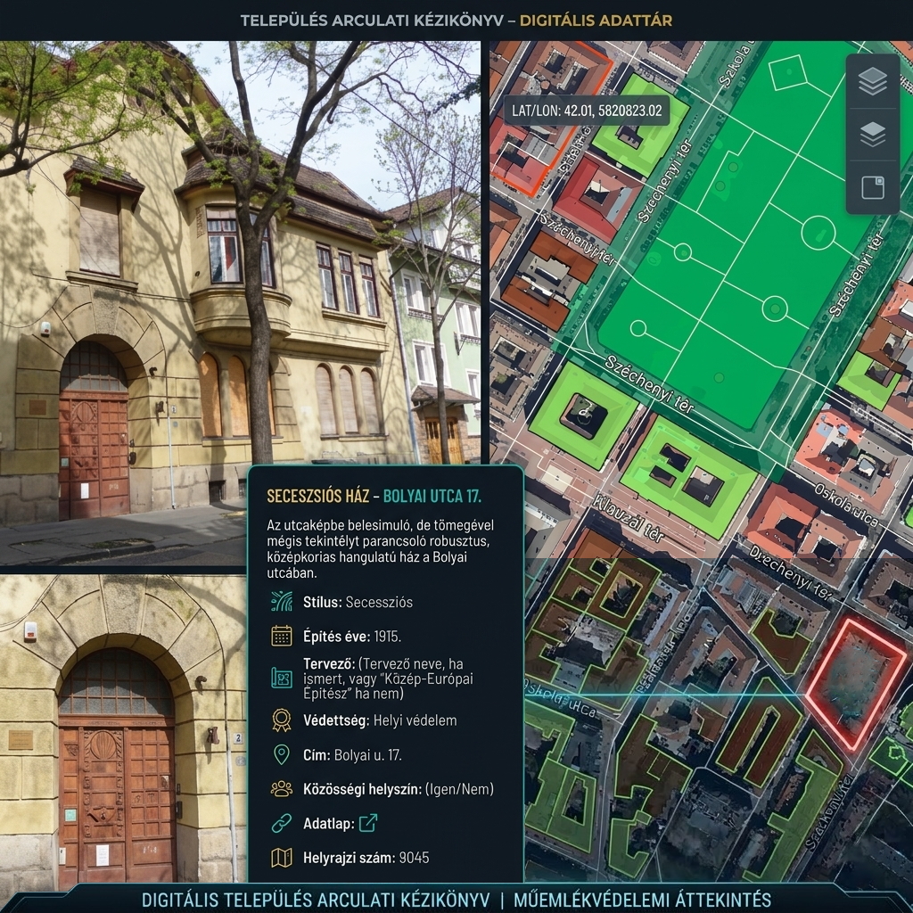
Visualisation of urban design manuals and building regulations for large cities
For villages and small towns
In addition to our urban geoinformatics systems, we have created a base package for villages, municipal associations, and small towns. A general sample can be viewed here.
Cemetery Cadastral Register
Our Cemetery Register System provides the most comprehensive data management for cemeteries. Following an extremely rapid data collection process, data from various sources can be queried in the appropriate logical order, visualised with geodetic geometric reliability, and exported from the cemetery database.
Managed Data
Plots, columbarium walls: data and overview photographs
Graves, niches: data and photographs
Deceased: data and documents
Burials: all burials chronologically
Exhumations: data
Clients and companies: basic data, contact details